


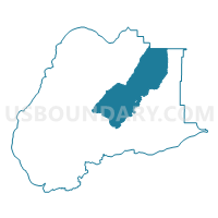
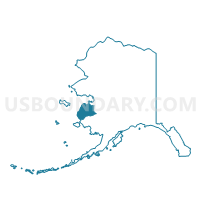
St. Mary's Precinct, Wade Hampton Census Area, Alaska
About
Outline

Summary
| Unique Area Identifier | 523558 |
| Name | St. Mary's Precinct |
| County | Wade Hampton Census Area |
| State | Alaska |
| Area (square miles) | 2,408.90 |
| Land Area (square miles) | 2,354.60 |
| Water Area (square miles) | 54.30 |
| % of Land Area | 97.75 |
| % of Water Area | 2.25 |
| Latitude of the Internal Point | 62.32809820 |
| Longtitude of the Internal Point | -162.69263670 |
Maps

Graphs
Select a template below for downloading or customizing gragh for St. Mary's Precinct, Wade Hampton Census Area, Alaska


Neighbors
Neighoring Voting District (by Name) Neighboring Voting District on the Map
- Kotlik Precinct, Wade Hampton Census Area, AK
- Marshall Precinct, Wade Hampton Census Area, AK
- Mountain Village Precinct, Wade Hampton Census Area, AK
- Pilot Station Precinct, Wade Hampton Census Area, AK
- Pitkas Point Precinct, Wade Hampton Census Area, AK
- St. Michael Precinct, Nome Census Area, AK
Top 10 Neighboring County Subdivision (by Population) Neighboring County Subdivision on the Map
- Nome census subarea, Nome Census Area, AK (9,492)
- Wade Hampton census subarea, Wade Hampton Census Area, AK (7,459)
Top 10 Neighboring Place (by Population) Neighboring Place on the Map
- Mountain Village city, AK (813)
- Pilot Station city, AK (568)
- St. Mary's city, AK (507)
- Pitkas Point CDP, AK (109)
Top 10 Neighboring Unified School District (by Population) Neighboring Unified School District on the Map
- Lower Yukon School District, AK (6,014)
- Bering Strait School District, AK (5,894)
- St. Marys City School District, AK (507)
Top 10 Neighboring State Legislative District Lower Chamber (by Population) Neighboring State Legislative District Lower Chamber on the Map
- State House District 39, Bering Straits, AK (15,642)
- State House District 6, Interior Villages, AK (14,235)